
PM Update: Pueblo Summit Fire
July 31, 2017
Pueblo Fire Update, Krassel Ranger District
The Pueblo Fire is burning in a steep drainage approximately 3/4 mile south of the Pueblo Summit Trailhead. The fire is estimated to be 10 acres, burning in subalpine fir with moderate fire spread. The fire is moving by single tree torching and spotting.
The fire is outside of, but within a mile of the Frank Church River of No Return Wilderness. The Forest has identified values at risk to be the Werdenhoff and Golden Hand mining areas, as well as the Pueblo Summit Road, Big Creek Trailhead and Big Creek administrative site.
The fire was called in by Sheepeater Lookout at 2:30pm Sunday, July 30. The Krassel Ranger District staffed the fire with smokejumpers and have used bucket drops of water from a light and a medium helicopter, and retardant drops from 3 Single Engine Air Tankers (SEATs).
Additional smokejumpers were assigned, and a 20 person Interagency Hotshot Crew was ordered, and arrived at Big Creek Sunday night.
Photo is from yesterday afternoon,
——————————————————–
Fire info: 208.634.0820
Access to Yellow Pine is not impacted by the fire. South Fork, Johnson Creek and Lick Creek roads are open. Watch out for fire traffic on the South Fork and EFSF Roads from Krassel to YP and from YP on the Stibnite Road to the turn off to Profile Creek Road. The Profile Creek Road is closed at the junction to Big Creek/Edwardsburg.
Profile Road is still closed to the public. Level 1 Evacuation Ordered for Big Creek/Edwardsburg (see below)
— —
Local Observations: Yesterday the high temperature was 96 degrees, haze of smoke all day. Overnight low of 47 degrees, clear sky this morning with a slight haze of smoke in the air.
— —
Road Report posted 7/30
Map of fire 7/27/2017 from GEOMAC (no growth)
(click on image to open larger size)
Missouri Fire Progression Map July 25 (no growth)

General location map for Missouri Fire July 17

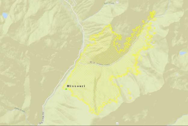
Missouri Fire Perimeter & Area Closure Map July 25

The Fire Camp has moved to Krassel and reduced in size.
Missouri Fire at InciWeb: https://inciweb.nwcg.gov/incident/5373/
— — —
Pueblo Summit Fire
July 30, 2017 444pm
We got a new smoke report from one of our lookouts this afternoon around 2:30. There is a new fire just south of Pueblo Summit. Looks to be 2-3 acres. At about 3:15pm, we put 8 smokejumpers on the fire and they are using 2 helicopters and 3 Single Engine Air Tankers (SEATs) with retardant.
That’s all we know currently, we will keep folks updated as we have more info.
Anthony B. Botello
District Ranger
Krassel Ranger District
— — — — — — — — — — — —
Missouri Fire
Monday, 31 July 2017
Contact Fire Information: 208.634.0820
PayetteFireInformation@gmail.com
http://www.inciweb.nwcg.gov/incident/5373/
Start Date: July 15
Cause: Lightning
Total Personnel 82
Size 1,277 Acres
Percent of Perimeter Contained 50%
On Sunday, July 30, 2017, the Missouri Fire was transitioned from a Type 2 Fire Management Team down to a smaller Type 3 Management Team. This was due to decreased fire activity, lower expected fire behavior in critical areas, stronger management lines, and an effort to lower suppression expenses. Fire management will continue the suppression and monitoring process and additional resources are readily available if needed.
The fire size has remained at 1,277 acres for the past week. While growth has stalled and the fire is not fully contained. There has been minimal fire activity, mainly in interior portions of the fire where occasional torching of isolated trees has been observed. It continues to smolder in heavy down fuels within the Frank Church-River of No Return Wilderness. Allowing fire to play its natural role in the ecosystem benefits the ecosystem. Fire is essential for soil renewal, wildlife habitat, and overall forest health.
The weather trend over the fire area for the next few days will become drier and warmer. However, winds are expected to be generally light hopefully keeping fire behavior and growth low.
In Edwardsburg and Big Creek, crews are clearing trees and brush from around Forest Service facilities and developed sites. Chippers will continue to be used to pulverize the removed trees and brush from both Profile Gap Road and within the community of Edwardsburg and Big Creek. The benefit of chipping is the ability to spread the materials over a large area which decreases the fuel loading. Chippers are still parked on the Profile Gap Road, making travel difficult for even the firefighters working in the area. For this reason, the road does remain closed despite the diminished fire threat along Profile Creek.
Evacuation Status: Level 1 evacuations are still in place for Edwardsburg/Big Creek, primarily due to the work taking place along the principal access route into the community. To the north, the road is passable with high-clearance vehicles, UTVs, and motorcycles; trailers are not recommended. Anyone who lives in the wildland urban interface should take time to consider what they would take in the event they did need to evacuate. The Ready, Set, Go Program (www.wildlandfirersg.org) has helpful tips for preparation.
Closures: The Payette National Forest implemented an area closure surrounding the fire area. Areas east of the Warren-Profile Road, north of Stibnite Road, and south of Lick Creek are closed. Maps and complete details of the closure can be found by visiting InciWeb. The Warren-Profile Gap Road remains closed.
YELLOW PINE IS OPEN !
For more information: Follow the Payette National Forest on Twitter at @Payette Forest, and on Facebook at U.S. Forest Service – Payette National Forest. Subscribe to email updates via GovDelivery at https://goo.gl/R2fDJr. Updates are emailed daily during times of heightened fire activity on the forest. Visit https://inciweb.nwcg.gov/ for more information on this and other fires throughout the nation. http://www.idahofireinfo.com for information on fires throughout the state of Idaho.https://inciweb.nwcg.gov/ for more information on this and other fires throughout the nation. And visit http://www.idahofireinfo.com for information on fires throughout the state of Idaho
— — — — — — — — — — — —
Level 1 – READY Evacuation Order Issued for Edwardsburg/Big Creek Area
Incident: Missouri Fire Wildfire
Released: 7/20 430pm
A Level 1 – A Ready evacuation order has been issued for the Edwardsburg/Big Creek area by Valley County Sheriff, Patti Bolen. This order is in effect until further notice.
This Level 1 – Ready evacuation order is a result of significant fire activity on the Missouri Fire located between Yellow Pine and Edwardsburg. The fire was actively burning yesterday, and is expected to have a continued active fire behavior.
Visit this link for all evacuation levels issued by Valley County:
http://www.co.valley.id.us/departments/sheriffs-office/valley-county-sheriff-evacutaion-policy/
— — — — — — — — — — — —
Recreational access in Big Creek and Edwardsburg
Incident: Missouri Fire Wildfire
Released: 7/20 2pm
Recreational access to the Edwardsburg/Big Creek area is not closed at this time, however; due to fire activity we strongly suggest that you choose an alternate location for recreational activities. An alternate entry into the Frank Church River of No Return Wilderness is through Thunder Mountain. The Payette National Forest has many great locations for camping, hiking, fishing, etc.
The closure of the Warren-Profile Gap Road between Yellow Pine and Edwardsburg/Big Creek is indefinite, but will open as soon as it is possible. If planning for an alternate route to Big Creek area, be aware that Valley County is warning that due to road damage from winter and spring storms, the Warren-Profile Gap road from Warren to the South Fork is not capable of handling large trucks or vehicles towing trailer. This route comes over Elk Summit into Big Creek. If you choose to take this route be cautious of increased two-way traffic on this narrow, winding dirt road.
Access to Yellow Pine is fully open, and we do not expect traffic to be impacted. Please be drive cautiously as fire vehicles are operating in the area.
Warning sign for Backcountry Travelers

— — — — — — — — — — — —
Payette Wilderness Fires
7/27/2017
The Payette National currently has 5 wildfires burning within the Frank Church River of No Return Wilderness. All of these fires are in a monitor status with no notable fire activity.
Rooster Creek Fire: (.10)acre) Lightning caused and report on July 26. Located 1/2 mile east of the South Fork of the Salmon River, northeast of Smith Knob on the McCall Ranger District. No vivible smke was noticed on July 27.
Lemhi Fire: (27 acres). Lightning caused and reported on July 16. Located along the Salmon River, 3.5 miles downriver of Campbell’s Ferry. Two fire personnel are assigned to the fire. Fire is in monitor status.
Stonebreaker Ranch Fire: (.25 acres). Lightning caused and reported on July 13. Located 1 mile north of Chamberlain Basin. No smoke showing currently. In monitor status.
Marble Mountain Fire: (3 acres). Lightning caused and reported on July 14. Located 2 miles southeast of Edwardsburg. Smokejumpers responded to this fire to aggressively prevent it from growing larger and spreading towards Edwardsburg. The fire was declared control and out on July 18.
Rocky Point Fire: (.10 acres). Lightning caused and reported on July 14. Located 10 miles north of Chamberlain Basin and 2 mile south of the Salmon River. No smoke is showing on this fire currently, and it is in a monitor status.
For up to date information, please contact the Krassel Ranger District at 208-634-0600., or the McCall Ranger District at 208-634-0400.
InciWeb link: https://inciweb.nwcg.gov/incident/5387/
— — — — — — — — — — — —
Wildhorse Fire
Monday, July 31, 2017
Contact: Kelsey Griffee, kgriffee@blm.gov, 208-521-8709
Twitter: @BLMIdahoFire(#WildhorseFire & #BLMIFDFire)
Start Date: 07/30/2017
Location and Jurisdiction: 6 miles South of Big Southern Butte about 35 miles west of Blackfoot, ID, BLM
Cause: Lightning
Fire Size: 25,000 acres
Percent Contained: Containment estimated for 7/31 at 8 p.m.
Fire Behavior: Minimal fire activity at the time of this release.
Structures Threatened: No immediate threat to structures.
Fuels and Terrain: Burning in grass and sage brush.
Fire Crews/Resources: 8 engines, 4 dozers, 1 water tender
Evacuations: None in effect at this time.
Closures: None.
Summary: The fire was reported on 7/30 around 3:30 p.m. and was caused by lightning from a storm that moved over the area with erratic, gusty winds. Crews estimated the fire at 2,000 acres an hour after it was reported. Multiple fire retardant drops were made on the fire last evening. The fire grew quickly due to wind and made large runs through the night due to extreme fire behavior. Fire activity is now minimal and resources will spend the day working to secure the fire perimeter.
Images taken yesterday, 7/30, by Engine Captain Austin Catlin


Link:
http://www.idahofireinfo.com/2017/07/wildhorse-fire.html
— — — — — — — — — — — —
NIFC
July 31, 2017
https://www.nifc.gov/fireInfo/nfn.htm
—————————————
