
Local Conditions: Much better air quality in the last few days. We had a couple little rain showers recently, not enough to settle the dust. Weather is still warmer than average for this time of year, but that will chance in the next couple of days.
Tonight Isolated showers and thunderstorms after midnight. Mostly cloudy, with a low around 49. West wind 5 to 8 mph becoming calm in the evening. Winds could gust as high as 20 mph. Chance of precipitation is 20%.
Thursday A 40 percent chance of showers. Mostly cloudy, with a high near 64. Calm wind becoming north northwest 5 to 7 mph in the afternoon.
Thursday Night A 50 percent chance of showers. Cloudy, with a low around 42. North wind 6 to 9 mph.
Friday Showers likely, mainly before noon. Cloudy, with a high near 53. North northwest wind 6 to 9 mph. Chance of precipitation is 60%.
Friday Night A 50 percent chance of showers. Mostly cloudy, with a low around 30. North northeast wind 5 to 11 mph.
Saturday A 20 percent chance of showers before noon. Sunny, with a high near 60.
Saturday Night Partly cloudy, with a low around 36.
Sunday A 20 percent chance of showers after noon. Partly sunny, with a high near 64.
Johnson Creek Airport WebCam
— — — —
Stage 1 Fire Restrictions in effect
Stage 1 Fire Restrictions Prohibit the the following:
* Building, maintaining, attending or using a fire, campfire, charcoal, coal or stove fire, except in designated recreation sites, and only within a metal and/or concrete fire structure provided by the forest service
* Personal charcoal grill
* Smoking, except within an enclosed vehicle or building, a designated recreation site or while stopped in an area at least three feet in diameter that is barren or cleared of all flammable materials
— — — —
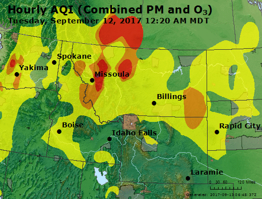
McCall Air Quality
Sept 12 smoke map
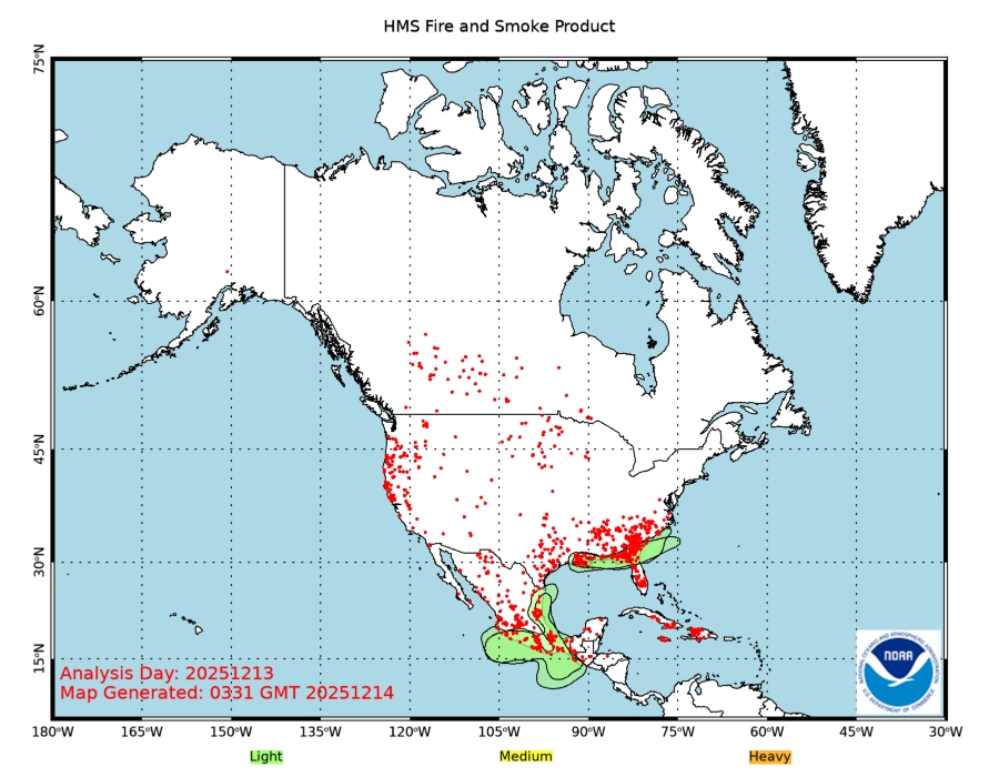
NOAA generates daily maps showing smoke patterns if you want to know where all the smoke is coming from:
— — — — — — — — — — — —
Bearskin Fire
Boise National Forest
Current as of 9/12/2017, 7:26:13 PM
Incident Type Wildfire
Cause Lightning
Date of Origin Wednesday August 23rd, 2017 approx. 07:30 PM
Location 21 miles NE of Lowman, Idaho – located in Valley County
Incident Commander M Quesinberry
Total Personnel 148
Size 29,100Acres
Estimated Containment Date Sunday October 01st, 2017 approx. 12:00 AM
Bearskin Fire Update – Wednesday, September 13, 2017
BOISE, Idaho – Fire management strategy on the Bearskin Fire continues to focus on ensuring National Forest System (NFS) road 579 remained clear following recent heavy equipment work and a high incidence of falling snags. Defensive firing to reduce the fuel load ahead of the fire began around Deadwood Lodge and approximately midway between the lodge and the intersection with NFS road 555.
Tuesday, engines from the Boise National Forest monitored fire activity along NFS road 579 to ensure safe passage for firefighters and equipment. Chainsaw crews broke up piles of fuel to further secure the side of the road closest to the fire while others worked on widening the indirect line established along NFS roads 579 and 555. Chipping of all green material was completed and prepping operations continued along NFS road 555 to the south toward Deadwood Reservoir. Good preparation work will ensure the area is ready for a safe and effective burn out as needed.
Today’s plan is to patrol and utilize point protection with crews and sprinklers around Deadwood Lodge, while crews continue to chip dead and down fuels along NFS road 579 to improve the indirect line. Engines continue to patrol the east side of the fire and hand crews and heavy equipment will work south below the second bridge on NFS road 555.
The Bearskin Fire has been full suppression since the start, but the management strategy had to be adapted to less available resources. While the confine and contain strategy has been safe and successful, the trade-off has been days with increased smoke and a fire that will likely last until it rains or snows. For information about smoke, please see http://idsmoke.blogspot.com/
The fire area will be partly cloudy Wednesday with a chance of showers and a slight chance of thunderstorms. Southwest winds from 3 to 8 mph are expected with the potential for gusts up to 20 mph with thunderstorm activity.
Public Information Officers (PIO) will be staged at specific locations and times daily to answer questions: In Stanley at the Visitor Information Center: 3:30 – 4:30 p.m., in Grandjean at the Sawtooth Lodge: 11:30 – 12:30 p.m., in Lowman at the District Rangers office: 9 – 10 a.m., in Crouch at the Community Hall: 11:30 – 12:30 p.m. and the Chevron in Garden Valley: 2:30 – 3:30 p.m. A PIO will also provide a fire update on KXGV 98.5 in Crouch every day at 11 a.m.
The Bearskin Fire area closure remains in place for public safety and includes the Deadwood Reservoir area and all the campgrounds and trails in the vicinity. NFS road 582 through Bear Valley remains open except between the junctions of NFS roads 545 and 515 which is closed for construction. Work is expected to last into October.
All Forest Closure Orders and maps are available at: https://www.fs.usda.gov/alerts/boise/alerts-noticeserts/boise/alerts-notices. Stage 1 fire restrictions are in effect on public and private lands under fire protection of the Boise National Forest, Boise BLM and State of Idaho. Campfires are only permitted in developed recreation sites with an agency approved metal fire ring. Smoking is allowed in a cleared area of at least 3 feet in diameter, in a vehicle or in a developed recreation site. For specific information visit: http://www.idahofireinfo.com/p/fire-restrictions.html
Point protection sprinkler near Deadwood Lodge Posted on: 09/11/17

InciWeb link: https://inciweb.nwcg.gov/incident/5536/
— — — — — — — — — — — —
Payette Wilderness Fires
9/13/2017, 9:29:41 AM
Goat Fire: (818 acres) Reported on August 20th. The fire is located in the Middle Fork of the Salmon River drainage. A management for ecological benefits strategy is being used for this wildfire. The Goat and Highline wildfires are being managed by a National Incident Management Organization (NIMO) Team.
Highline Fire: (83,630 acres) Camberlain Airstrip is Closed. An area closure order is in effect. The Highline and Goat wildfires are being managed by a National Incident Management Organization (NIMO) Team.
Jackson Bar Fire: (30 acres) This wildfire was reported the evening of August 15th. This wildfire is controlled at this time, and fire activity has not been observed since August 19th.
Missouri Fire: (1,277 acres) The Missouri Fire has not been active for a extended amount of time, however heat does still exist in the interior of the fire perimeter. Smoke was noted from this fire on August 19th. T he portion that is within the Frank Church River of No Return wilderness is being managed under a strategy of wildfire for resource benefit. The portion outside of the wilderness area is being monitored. The Warren-Profile Gap Road between Yellow Pine and Edwardsburg/Big Creek is open to the public, but motorists are advised to watch for fire related traffic. Valley County lifted the Level 1 -Ready Evacuation Order for the Edwardsburg/Big Creek area. The area closure that was implemented by the Forest has been lifted. This lightning-caused fire started on the Missouri Ridge on July 15. Firefighting resources quickly responded with ground crews and fire aviation equipment.
Pueblo Fire: (20 acres) This fire was contained as on August 3rd at 6:15p.m., and has been declared out. The Pueblo Fire is located just outside the wilderness approximately 6 miles north of Big Creek/Edwardsburg near Pueblo Summit and east of the Mosquito Ridge. A suppression (contain and confine) strategy was used on the Pueblo Fire with objectives of protecting the values of risk in the area.
Magpie Fire: (.10 acres) Lightning caused and reported on July 27. Located near White Bird Meadows, 3 miles south of the Salmon River. Minimal fire activity observed. This wildfire has been declared out.
Big Bear Fire: (.20 acres) Lightning caused and reported on July 26. Located 8 miles northeast of Chamberlain Basin and 5 mile south of the Salmon River. This wildfire has been declared out.
Rooster Creek Fire: (.10 acre) Lightning caused and report on July 26. Located 1/2 mile east of the South Fork of the Salmon River, northeast of Smith Knob on the McCall Ranger District. This wildfire has been declared out.
Lemhi Fire: (28 acres) Lightning caused and reported on July 16. Located along the Salmon River, 3.5 miles downriver of Campbell’s Ferry. This wildfire is in monitor status.
Stonebreaker Ranch Fire: (.25 acres). Lightning caused and reported on July 13. Located 1 mile north of Chamberlain Basin. This wildfire has been consumed by the Highline wildfire.
Marble Mountain Fire: (3 acres) Lightning caused and reported on July 14. Located 2 miles southeast of Edwardsburg. Smokejumpers responded to this fire to aggressively prevent it from growing larger and spreading towards Edwardsburg. This wildfire was declared out on July 18.
Rocky Point Fire: (.10 acres) Lightning caused and reported on July 14. Located 10 miles north of Chamberlain Basin and 2 mile south of the Salmon River. This wildfire has been declared as out.
For additional information on this wildfires, please contact the Krassel Ranger District at 208-634-0600, or the McCall Ranger District at 208-634-0400.
InciWeb link: https://inciweb.nwcg.gov/incident/5387/
— — — — — — — — — — — —
Highline Fire
Payette National Forest
Current as of 9/13/2017, 6:41:28 PM
Incident Type Wildfire
Date of Origin Saturday July 29th, 2017 approx. 12:00 AM
Incident Description Wildfire Burning Within The Frank Church River Of No Return Wilderness
Incident Commander Joe Reinarz, Incident Commander, National Incident Management Organization (NIMO)
Total Personnel 83
Size 83,630 Acres
Current Situation: Fire behavior yesterday on the Highline and Goat fires remain generally low to moderate. Cooler and wetter conditions are forecast to enter the fire area bringing reduced fire behavior and spread potential through at least Friday. The Highline fire’s eastern perimeter continues to slowly back towards Root Ranch and Arctic Point Lookout. The fires edge west of Root Ranch has moved down into Ranch Creek and is within one half mile of the Ranch. Fire along the northern tip continues to burn in the top of Harlan Creek and backing slowly down toward the Salmon River remaining high on the breaks. The fire’s western flank continues to back slowly to the west towards Sheepeater Lookout, with pockets of active fire observed around Flossie Lake, Chamberlain Basin, Upper Red Top Meadows and Moose Creek. The southwestern portion of the fire continues to burn actively in areas of timber northeast of Rock Rabbit Lookout. Fire spread on the southern perimeter is mostly backing, but some active runs are occurring when winds, slope and fuels are aligned. The Goat fire continues to back at a very slow rate down towards Phantom Creek and the Salmon River. A new Area Closure Order has gone into effect. The revised order reopens the south and southeast corner of the fire area that had been closed on September 4. The updated Area Closure Order reopens the Big Creek Trail #196 and everything south of the trail as well as adjusting the east boundary to the west to allow the airstrips at Cold Meadows, Cabin Creek and Soldier Bar to open. A new fire start was discovered two miles southwest of Sheepeater Lookout yesterday. It was reported as one tenth of an acre and smoldering in grass and downed fuels. Two firefighters were delivered by helicopter to take suppression action on the new start. Firefighters will continue monitoring the fire by air for movement that may prompt protection actions. Resources assigned include: one type 2 initial attack crew; one local hand crew; one fire use module; one light helicopter; and fireline leadership and support positions. A total of 83 personnel are assigned.
Highline Fire Facts – September 13, 2017
https://inciweb.nwcg.gov/incident/article/5500/40887/
Highline Fire Area Closure Reduced
McCall, Idaho – The Highline Fire Area Closure Order that has been in place since September 4, is being modified to encompass fewer acres.
Weather conditions and fire behavior on the Highline and Goat fires has moderated in recent days to allow Payette forest managers to make changes to the current closure area.
The revised order opens the southeast corner of the area that had been closed as the Highline fire moved in that direction.
The changes to the Area Closure Order include opening the Big Creek Trail #196 and everything south of the trail as well adjusting the east boundary to the west to allow the Cold Meadows, Cabin Creek and Soldier Bar airstrips to reopen.
The rest of the area included in the original closure including Chamberlain airstrip remain closed for public safety and protection of hazards due to ongoing fire activity.
Please visit https://www.fs.usda.gov/alerts/payette/alerts-notices to see the updated Area Closure Order and Map.
Highline Fire Closure Order – September 13, 2017
https://inciweb.nwcg.gov/incident/article/5387/40899/
Highline Fire Area Closure Map, Sept 13, 2017

Highline fire overview map Posted on: 09/13/17

Fire burns around Rock Rabbit Lookout Posted on: 09/13/17

InciWeb link: https://inciweb.nwcg.gov/incident/5500/
— — — — — — — — — — — —
Salmon-Challis 2017 Wilderness Fires
Honeymoon Fire
Salmon-Challis National Forest
Current as of 9/13/2017, 4:54:10 PM
Incident Type Wildfire
Cause Lightning
Date of Origin Sunday August 27th, 2017 approx. 02:00 PM
Location Frank Church River of No Return Wilderness, 30 NM NW of Stanely, ID
Incident Commander Severe
Incident Description The Fire Is Being Allowed To Play, As Nearly As Possible, Its Natural Ecological Role In The Environment While Providing For Firefighter And Public Safety.
Current Situation
Total Personnel 7
Size 1,860 Acres
Estimated Containment Date Tuesday October 31st, 2017 approx. 12:00 PM
InciWeb link: https://inciweb.nwcg.gov/incident/5543/
— — —
Tappan Fire
Salmon-Challis National Forest
Current as of 9/13/2017, 4:53:47 PM
Incident Type Wildfire
Cause Human And Is Currently Under Investigation
Date of Origin Tuesday August 01st, 2017 approx. 07:00 PM
Location On the Middle Fork and North Fork Ranger Districts, near the confluence of Camas Creek and the Middle Fork of the Salmon River. Fire is located east of the Middle Fork of the Salmon River
Incident Description Fire Is Located East Of The Middle Fork Of The Salmon River In Steep, Rocky, And Inaccessible Terrain.
Total Personnel 1
Size 1,650 Acres
The fire is in monitor status under the direction of the North Zone Duty Officer. The fire has not increased in size and fire activity remains in the interior of the burn perimeter.
InciWeb link: https://inciweb.nwcg.gov/incident/5458/
— — —
Ibex Fire
Salmon-Challis National Forest
Current as of 9/13/2017, 3:25:34 PM
Incident Type Wildfire
Date of Origin Monday July 24th, 2017 approx. 03:45 PM
Location 23 miles NW of Challis, Idaho
Incident Commander Rhoades/Waverek(t)
Total Personnel 15
Size 17,256 Acres
Estimated Containment Date Monday October 30th, 2017 approx. 12:00 AM
InciWeb link: https://inciweb.nwcg.gov/incident/5426/
— — — — — — — — — — — —
Nez Perce-Clearwater National Forests Fire Updates
Coolwater Complex
Nez Perce – Clearwater National Forests
Current as of 9/13/2017, 11:41:23 AM
Incident Type Wildfire
Cause Lightning/ Natural
Date of Origin Thursday September 07th, 2017 approx. 02:30 PM
Location Near Andy’s Lake and Coolwater Mountain
Incident Commander Steve Goldman, Eastern Area IMT
Total Personnel 121
Size 2,969 Acres
Percent of Perimeter Contained 4%
On September 9 the Andy’s Hump, Old Man and Glover fires were all combined into the Coolwater Complex under Steve Goldman’s Eastern Area Incident Management Team.
InciWeb link: https://inciweb.nwcg.gov/incident/5597/
— — —
Big Elk Fire
Nez Perce – Clearwater National Forests
Current as of 9/13/2017, 11:21:22 AM
Incident Type Wildfire
Date of Origin Friday September 08th, 2017 approx. 01:00 PM
Location Big Elk Creek
Incident Commander Chris Young, Type 3 IC
Total Personnel 62
Size 80 Acres
Big Elk Fire Update – Sept 13
On the Big Elk fire (approx. 80 acres) Tuesday, fire activity was minimal with no growth, although there was some torching in the interior which may continue. Chris Young, IC Type 3, expects to release a portion of the resources assigned at end of shift today and to possibly return responsibility for the fire to the district on Thursday.
InciWeb link: https://inciweb.nwcg.gov/incident/5602/
— — —
Hanover Fire
Nez Perce – Clearwater National Forests
Current as of 9/13/2017, 11:11:37 AM
Incident Type Wildfire
Cause Lightning/natural
Date of Origin Tuesday August 01st, 2017 approx. 12:30 PM
Location South of Grangeville, ID and northeast of Riggins, ID
Incident Commander Kevin Barger, Type 3 IC
Total Personnel 40
Size 26,500 Acres
Percent of Perimeter Contained 88%
Hanover Fire Update – Sept 13
Cloud cover prevented good infrared mapping Tuesday night for Hanover fire (26,342 acres), but patrol shows the fire has moved over Round Top to the north and is backing into Slate Creek. On the east, the fire holds in Sheep Creek, slowing moving north in the drainage. Some activity continues in Little Boulder Creek to the west. The fire remains heavily patrolled and containment lines actively monitored. If conditions allow, more helicopter work will be done today. Ground crews, engines, heavy equipment and helicopters remain assigned to the incident. The Twin Lakes fire is estimated at 30 acres and is being managed with the Hanover fire.
InciWeb link: https://inciweb.nwcg.gov/incident/5459/
— — —
Buck Lake Fire
Nez Perce – Clearwater National Forests
Current as of 9/7/2017, 8:33:21 AM
Incident Type Wildfire
Cause Lightning/natural
Date of Origin Wednesday August 02nd, 2017 approx. 05:00 PM
Location 19 Miles NE of Elk City, Idaho
Incident Commander Tim Schaeffer, Type 4 IC
Size 2,316 Acres
Estimated Containment Date Friday December 01st, 2017 approx. 12:00 AM
This incident is being managed for long-term resource benefits and is being patrolled and monitored as it continues to perform its natural role across the landscape.
InciWeb link: https://inciweb.nwcg.gov/incident/5561/
— — —
Chute Creek Fire
Nez Perce – Clearwater National Forests
Current as of 9/11/2017, 11:50:56 AM
Incident Type Wildfire
Cause Lightning/natural
Date of Origin Sunday August 13th, 2017 approx. 09:00 AM
Location 2.5 miles west of Blodgett Lake, 16.7 miles west of Hamilton, Montana
Incident Commander Tim Schaeffer, Type 4 IC
Size 3,683 Acres
Estimated Containment Date Monday October 02nd, 2017 approx. 12:00 AM
This incident will only be updated in the event of significant change in fire behavior or acreage.
InciWeb link: https://inciweb.nwcg.gov/incident/5515/
— — —
Pronghorn Fire
Nez Perce – Clearwater National Forests
Current as of 9/11/2017, 1:02:20 PM
Incident Type Wildfire
Cause Lightning/natural
Location Matteson Ridge
Incident Commander Jodi Baxter, Type 3 IC
Total Personnel 19
Size 78 Acres
Estimated Containment Date Saturday October 07th, 2017 approx. 12:00 AM
InciWeb link: https://inciweb.nwcg.gov/incident/5587/
— — —
Lone Pine Fire
Nez Perce – Clearwater National Forests
Current as of 9/1/2017, 2:19:56 PM
Incident Type Wildfire
Cause Lightning/natural
Date of Origin Friday July 14th, 2017 approx. 05:45 PM
Location Below Lone Pine Point in the Selway Bitterroot Wilderness
Incident Commander Jim Wimer, Type 4 IC
Size 10,152 Acres
The Lone Pine fire started July 14 below Lone Pine Point, a very remote area in the Selway Bitterroot Wilderness. The fire is being managed for long-term resource benefit, using a point protection strategy. Smoke will be obvious along the Selway River corridor. Extreme caution should be used along the river as trees may continue falling in and around the river.
InciWeb link: https://inciweb.nwcg.gov/incident/5456/
— — —
Moose Creek 1 Fire
Nez Perce – Clearwater National Forests
Current as of 9/10/2017, 10:11:21 AM
Incident Type Wildfire
Cause Lightening/natural
Date of Origin Friday July 14th, 2017 approx. 04:03 PM
Location Southeast of the Historic Moose Creek Ranger Station
Incident Commander Roy Angeny, Type 4 IC
Total Personnel 12
Size 17,395 Acres
Estimated Containment Date Sunday October 01st, 2017 approx. 06:00 PM
This incident will only be updated when fire behavior or acreage shows significant change.
InciWeb link: https://inciweb.nwcg.gov/incident/5405/
— — —
Rattlesnake Point Fire
Nez Perce – Clearwater National Forests
Current as of 9/11/2017, 2:02:51 PM
Incident Type Wildfire
Cause Lightning/natural
Date of Origin Monday August 14th, 2017 approx. 05:45 PM
Location Rattlesnake Point – Frank Church River of No Return Wilderness
Incident Commander Unstaffed
Size 4,843 Acres
Estimated Containment Date Sunday October 01st, 2017 approx. 12:00 AM
Area Closure Lifted on Rattlesnake Point Fire
The area closure which resulted from the Rattlesnake Point and other fires has been lifted.
InciWeb link: https://inciweb.nwcg.gov/incident/5442/
— — —
Hidden Fire
Nez Perce – Clearwater National Forests
Current as of 9/12/2017, 12:04:59 PM
Incident Type Wildfire
Cause Lightning/natural
Date of Origin Monday July 10th, 2017 approx. 04:15 PM
Location Hidden Ridge, 7 mi. NE of Elk Summit Guard Station
Incident Commander Stony Nelson, ICT3
Size 12,261 Acres
Estimated Containment Date Saturday October 21st, 2017 approx. 12:00 AM
InciWeb link: https://inciweb.nwcg.gov/incident/5446/
— — — — — — — — — — — —
Strychnine Fire
Idaho Department of Lands
Current as of 9/13/2017, 8:28:01 AM
Incident Type Wildfire
Date of Origin Saturday September 02nd, 2017 approx. 03:30 PM
Location 4.5 miles northeast of Harvard, ID
Incident Commander Idaho Department of Lands- Jason Svancara Type 3 IC
Total Personnel 140
Size 1,010 Acres
Percent of Perimeter Contained 50%
Strychnine Fire FINAL Fact Sheet 9/11/17
https://inciweb.nwcg.gov/incident/article/5586/40726/
InciWeb link: https://inciweb.nwcg.gov/incident/5586/
— — — — — — — — — — — —
North Fork Hughes Fire
Idaho Panhandle National Forest
Current as of 9/12/2017, 12:33:44 PM
Incident Type Wildfire
Cause Lightning
Date of Origin Wednesday June 28th, 2017 approx. 12:00 AM
Location 20 miles North of Nordman, Idaho
Incident Commander Glen Palfrey
Total Personnel 11
Size 3,931 Acres
InciWeb link: https://inciweb.nwcg.gov/incident/5343/
— — — — — — — — — — — —
Buck Fire
Idaho Panhandle National Forest
Current as of 9/13/2017, 5:04:38 PM
Incident Type Wildfire
Date of Origin Monday August 07th, 2017 approx. 06:45 PM
Incident Commander Local unit
Incident Description Located Approximately 17 Miles Southeast Of Avery, Idaho
Total Personnel 55
Size 1,800 Acres
Percent of Perimeter Contained 10%
The Buck Fire is located on the St. Joe Ranger District, approximately 17 miles southeast of Avery, Idaho. The fire is burning in steep terrain and heavy fuels along Buck Creek, south of FSR201.
InciWeb link: https://inciweb.nwcg.gov/incident/5493/
— — — — — — — — — — — —
National Interagency Fire Center
September 13, 2017
More than 21,000 firefighters are assigned to wildfires fires in 10 western states. Favorable weather conditions are helping firefighters make progress toward containment goals.
Weather: The upper level low pressure system along the California Coast will move on shore into the state as another system approaching from the Gulf of Alaska begins to approach the West from the northwest. These two systems will begin to merge in the afternoon and will spread widespread showers with embedded storms across the northwestern quarter of the country. To the east, hot and dry conditions will continue across the Great Plains as the high pressure ridge moves east. Meanwhile the remnants of Irma will drift southward into the southern Tennessee River Valley continuing the persistent rainfall, possibly creating some flooding concerns.
States currently reporting large fires:
California (7)
Colorado (2)
Idaho (3)
Montana (21)
Nevada (1)
Oregon (17)
South Dakota (1)
Utah (1)
Washington (8)
Wyoming (1)
https://www.nifc.gov/fireInfo/nfn.htm
— — — —
Fires 9/13/2017

—————————————
